Cultural Tours
Safari Tours
Trekking Tours
- Gangabal - Trek
- Lamayaru Alchi - Trek
- Lamayaru Darcha - Trek
- Marcha - Trek
- Spituk - Trek
- Water - Trek
- Zanaskar - Trek
Rafting
Beaches
Angling
Ecotourism
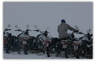
Bike Safari
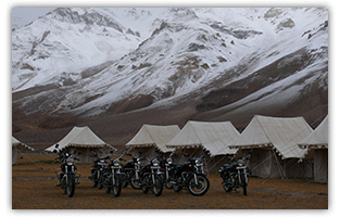 Motorbike Safari Tour to The Top of The World
This tour starts from Manali after arrival at Delhi Airport. Manali is the famous hill station of India and this "Motorbike Safari Tour to The Top of The World" tour passes with the hired motorbikes and cross famous passes Manali, Leh - Ladakh region which is located in State of Jammu & Kashmir. Ladakh, the largest of the ten provinces of Jammu and Kashmir is bordered by the Karakorm chain of mountains in the north and Himalayas in the south. Ladakh is the land of towering mountains and Buddhist simplicity.
Duration:16 Days/15 Nights
Places Covered : Manali - Marrhi Nallah - Marrhi - Rohtang - Koksar - Sissu Gondla - Tandi - Keylong - Gemur -Jispa –Darcha- Patseo Baralacha La-Bharatpur -Sarchu- 4253 M - Brandy Nallah Gata loops - Naki la - Lachungla - Pang - Tanglangla (Base Camp)
Day01: Arrive Delhi
On arrival meeting, assistance & transfer to Hotel. Afternoon proceed for half day city tour of New Delhi. Visit India Gate, Laxminarayan Temple, Qutab Minar, Lotus Temple and drive past President and the Parliament house. Return to hotel for Overnight
Day02: Delhi-Manali
Drive from Delhi to Manali by A/C Coach or Car (505Km/7Hrs to 8 Hrs )Check in hotel.Meals and overnight at Hotel.
Day03: Manali-MarrhiNallah(drive)
second day, the tour will start early and cross the Beas river over Manali town bridge in the middle of the market & proceed to Palchan the Army Check post. The Beas river flows on the left side of the road. Passing through a small Hamlet town we take the first set of hairpin bends on the Serpentine road on the road to Rohtang. Be prepared to a total contrast in weather from the partly sunny Manali. There may be fog and mild rain. Arrive Marhi (40Km) & Over night stay in the camp.
Day04: Marrhi - Rohtang - Koksar - Sissu - Gondla - (70 KMS)
Morning drive to Rohtang Pass It is the highest point 4,112m, on the Manali-Keylong road, 51km from Manali town. It provides a wide panoramic view of mountains rising far above clouds, which is a sight truly breath-taking. You can see scenic views of snow-covered peaks & Glaciers in the far horizon. As we descend there is change in vegetation, the tree line seems to be getting away from us making way for small bushes. We are in the foothills of the Pir Panjal Range (The Pir Panjal Range constitutes the first mountain rampart associated with the Himalayas. It has an average crest line of 12,500ft or 3,800 meters, with individual peaks rising to some 15,000 feet or 4,600 meters. Consisting of an ancient rock core of granites, gneisses, quartz rocks, and slates, it has been subject to considerable uplift and fracturing). After crossing the check post follow the river flow till Tandi. At certain points we will abandon the bank, climbing uphill but we will be moving more or less along the river. We will encounter some unmetalled stretches of road today after Koksar till Gondla, & cross a few mountain streams flowing over the road. Over Night in the Camp.
 Day05: Tandi-Keylong-Gemur-Jispa-Darcha
In the morning at the confluence point of River Chandra & Bhaga we will cross the bridge and proceed uphill to Keylong town. As we ascend the serpentine road into a gorge we will come across Gemur. As we come out of the gorge and descend downhill we will reach the Jispa hamlet town. It's again a green belt for sometime where we will see many shepherds and their sheep scattered on the hillsides. We are almost in the Land of Lamas now. After crossing Jispa one is definitely in an isolated region & in far horizon we can distinctively see the bareness of the Higher Himalayan ranges. Overnight stay in Darcha, which is 45 Km from Tandi. Darcha can be considered the gateway to the Higher Himalayas.
Day06: Darcha-Patseo-BaralachaLa-Bharatpur
In the morning we will cross the bridge & proceed on the hairpin bends uphill. Now it is going to be all ascend till we come to the cantonment area of military garrison of Himmatnagar. Now, we are in the flat area & then ride through the hairpin bends of Patseo & Zing Zing Bar as we move into the harsh terrain of the arid mountains. Now we will ascend the heights of the Baralacha Pass 4892 m and Suraj Tal Lake. Now it is the time for mountain river crossings. Twice we will be in the middle of water. We will descend down to the gorge area of Bharatpur, which is 55Km from Darcha & Over night stay.
Day07: Bharatpur-Sarchu-4253M-BrandyNallah-(35KMS)
The Day starts with an easy ride on a flat road, downhill & then entering a gorge descending to the bridge connecting to the Sarchu Plateau. Cross over the bridge & we move ahead ascending a small uphill road making us move to the plateau area & now ahead lies another vast stretch flat ground with shepherds and their mountain goats. There are a number of features of arid landscapes with some beautiful scenery, a delight for photographers who are looking for high rise mountain ranges, bearing water marks & erosion of soil clearly indicating that the area was under water a few million years ago. The area is sparsely green, the wind is chilly & fast blowing here. We are at the Traffic Check post, which is the entry point into Ladakh. Another 20 Kms ahead on the base of the Gata loops hair pin bends we will camp for the night at Brandy Nallah.
Day08: Brandy Nallah-Gata loops-Naki la-Lachungla-Pang
After an easy day yesterday we now move to scale the Gata loops, 23 hairpin bends bringing us top of the mountain feature. We ride up hill, over an easy slope only to cross the Naki La pass, descend down into the gorge to an isolated military garrison area & then ascend again to the height of the Lachulung la 5065 M. After Naki La we are almost on an unmetalled stretch of gravelly road all the way inside the gorge of Pang, which is 57Km far from Brandy Nallah. Over Night stay in the Camp.
Day09: Pang-MorePlains-Tanglangla(Base Camp)
Eight Kms uphill from the Bowl-like feature of Pang we come to the plateau area of the More plains. Changpas, the Nomadic people who tend their yaks here and a few wild asses are the only sign of life on this isolated and long road. This belt not only barren but is known for fast blowing winds, sandstorms & extreme temperatures in the early morning and evenings. Fresh stream water can be considered a scarcity in this area though you would enjoy isolated mountain streams flowing down from the Tanglangla, which is 47Km far from Pang. Over Night in the Camp.
Day10: Tanglangla-Rumtse-Gya
We proceed early to scale the World's second highest pass, Tanglang la 5,360 M. The ride for the next 17 Kms is a challenge for even the fittest of riders, weather being cold early in the morning, with gravelly stretches of the road consuming extra energy, riding over the altitude of 17,000 Ft will be an acid test for the mind & Body. Reaching the top is a very satisfying experience & then it's all down hill with smooth gradients till the base of the Pass. After crossing a small mountain river it is time to find civilisation again! The Chortens along the road in the villages announce our arrival in the heart of Buddhist culture. The greenery changes the landscape, and the red mountains surrounding us and reflected in the river only add to the beauty as we hit Rumtse and Gya. Gya is 50 Km from Tanglangla & over night stay in the camp.
 Day11: Gya-Upshi-Karu-Leh
For next 20 Kms we ride on some metalled & unmetalled stretches of roads & cross over the Upshi bridge across the river Indus. The river originates in China & crosses over into India. The road condition improves considerably as we follow more traffic from the cantonment area & local villages going to Leh. Ahead lies the Thiksey Monastery & the Chortens Garden before we finally enter Leh Town. The ride is easy & we can expect to reach Leh by evening. Leh is 61Km from Gya & O/N stay in the Hotel.
Day12: Leh
Day free for leisure, pleasure & relaxction. & maintenance of the Bicycles. A comfortable bed, hot water and a relaxed day is the only way to be after the tough conditions we have ridden over in the last few days!
Day13: Leh-Khardungla-5602
Morning drive to Khardung La (La means Pass in Tibetan, the local language) in the Ladakh region, Jammu and Kashmir, India, is arguably the world's highest motorable mountain pass at a height of 5,682 m (18,640 feet). The pass, on the Karakoram range in South Pullu, lies 40 km north of Leh and is the gateway to the Nubra Valley where the Siachen Glacier lies. Built in 1976, it was opened to motor vehicles in 1988 and has since seen many automobile, motorbike and mountain biking expeditions). The journey from Leh till the North Pullu Check post, Appx 20 Kms, is fair enough to warm up, with some easy uphill ride. After North Pullu one has to gear up more. The roads are under maintenance & construction thus the ride is bumpy & as we proceed ahead it becomes a gravel track & the ride becomes more and more challenging. But reaching the top is worth every bit of the effort and sweat! Its the highest motor able pass in the world, and not many dare to bicycle their way up to 18,380 Ft. The Truck awaits on top of Khardung la for the cycles to be loaded and brought back to Leh town. We will ride back comfortably in 4 Wheel drive vehicles taking time for photography. Over Night in Leh.
Day14: Leh
Morning visit the surrounding areas of Leh for a sight seeing trip.Meals ans . Over Night in Hotel.
Day15: Leh-Delhi(Fly)
Early morning transfer to Leh Airport Fly to Delhi. Arrive & check in the Hotel. Spend the day at leisure and take the flight to Delhi. Overnight at Delhi Hotel.
Day 16: Departure
its time to say goodbye. In time transfer to international airport to connect flight for onward
journey.
Information
- Sunblock -(In India Biotique has SPF 75)
- Moisturiser - Heavy duty
- Shampoo & conditioner
- At least one camera roll for each day - if you are trigger happy
- Half the clothes you planned
- Double the money you've budgeted
- Common medication
- Water and candies
- Shades and a hat
- A positive attitude
Road Conditions: -
Shimla To Manali - Very Good
Manali To Koksar - (After Rohtang) - Good
Koksar To Keylang - Bad
Keyland To Zingzing Bar - Good
Zingzing Bar To Sarchu - Very Bad
Sarchu To Leh - Very Good
Leh To Lamayuru - Very Good
Leh To Hunger - Very Good
Leh To Pangong - Very Good